Earth’s Magnetic Field
Contents
Introduction
Earth’s magnetic field, also known as the geomagnetic field, is an invisible force field that originates from the planet’s core and extends thousands of kilometers into space, creating a protective magnetic bubble called the magnetosphere. This magnetic field is fundamental to life on Earth, serving as a protective shield against harmful solar radiation and cosmic rays while also playing crucial roles in navigation, animal migration, and geological processes.
Origin and Generation of Earth’s Magnetic Field
The Geodynamo Process
The Earth’s magnetic field is generated through a mechanism known as the dynamo theory or geodynamo process. This natural phenomenon occurs in the Earth’s outer core, where specific conditions combine to create and sustain the magnetic field:
Key Components:
The outer core consists of molten iron and nickel at temperatures ranging from 4,400°C at the outer regions to 6,000°C near the inner core
These liquid metals exist under lower pressure than the solid inner core, maintaining their fluid state
Convection currents arise due to differences in temperature, pressure, and composition within the outer core
The Generation Process:
The mechanism works through the following sequence: molten iron and nickel in the outer core undergo convection, creating movement of electrically charged particles. This flow of charged metals generates electric currents, which in turn produce magnetic fields. These magnetic fields then influence other charged particles passing through them, creating additional electric currents. This self-sustaining cycle, reinforced by the Coriolis effect from Earth’s rotation, maintains the geodynamo.
Structure and Components of the Magnetic Field
Basic Configuration
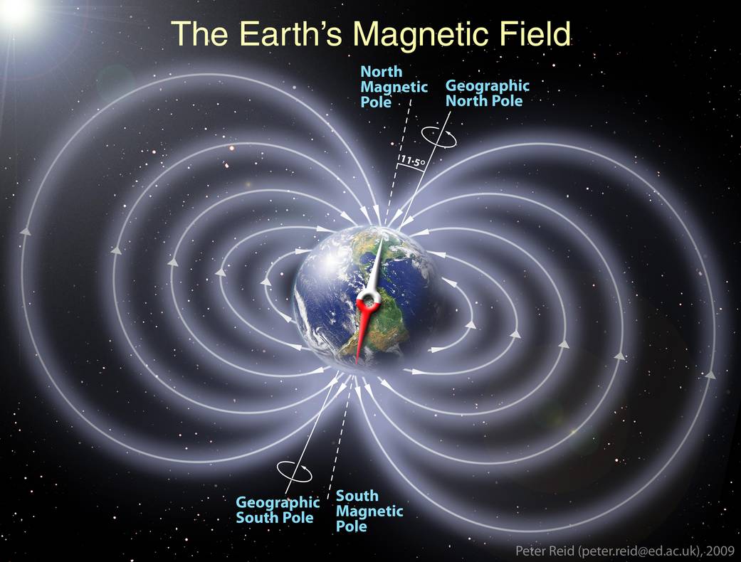
Earth behaves like a giant dipole magnet, similar to a bar magnet with distinct north and south poles. However, there is an important reversal: the geomagnetic south pole is located near the geographic north pole, and vice versa. This explains why the north pole of a compass needle (which is actually a magnetic north pole) points toward Earth’s geographic north.
The Magnetosphere
The magnetosphere extends approximately 60,000 to 70,000 kilometers above Earth’s surface. However, this protective bubble is not spherical but rather teardrop-shaped due to interaction with solar wind:
On the dayside (facing the Sun), the magnetosphere is compressed to about 63,000 kilometers from Earth’s surface due to solar wind pressure
On the nightside (opposite the Sun), it stretches out millions of kilometers into space, forming a long magnetotail
Magnetic Field Components and Measurement
To completely describe Earth’s magnetic field at any location, scientists use seven interrelated parameters that define both the direction and intensity of the field:
Directional Elements
Magnetic Declination (D): The angle between true north (geographic north) and magnetic north on the horizontal plane. Declination is measured in degrees, positive when measured east of true north and negative when west.
Magnetic Inclination (I) or Angle of Dip: The angle between the horizontal plane and the total magnetic field vector. At the magnetic equator, the inclination is 0° (horizontal), while at the magnetic poles it is 90° (vertical). The inclination is measured positive when pointing downward.
Intensity Elements
Total Intensity (F): The complete strength of the magnetic field vector at a point
Horizontal Component (H): The component of the magnetic field parallel to Earth’s surface
Vertical Component (Z): The component perpendicular to Earth’s surface, by convention positive downward
North Component (X): The component along the geographic north direction
East Component (Y): The component along the geographic east direction
Measurement Units
The magnetic field strength is measured in nanotesla (nT), where 1 nT = 10⁻⁹ Tesla. Earth’s magnetic field intensity ranges between 25,000 to 65,000 nT (0.25 to 0.65 gauss) depending on location. For comparison, the ancient magnetic field detected in 3.7 billion-year-old rocks had a strength of at least 15 microtesla (15,000 nT), comparable to today’s field of around 30 microtesla (30,000 nT).
Functions and Importance of Earth’s Magnetic Field
Protection from Solar Radiation
The magnetosphere acts as Earth’s primary defense mechanism against harmful space radiation. It shields the planet from:
Solar Wind: A continuous stream of electrically charged particles (mainly protons and electrons) emitted by the Sun at speeds of approximately one million miles per hour
Cosmic Rays: High-energy radiation from star explosions and deep space that travels constantly through the universe
Solar Flares and Coronal Mass Ejections: Intense bursts of radiation and plasma from the Sun’s surface
The magnetic field deflects most of these charged particles by exerting the Lorentz Force, which acts at right angles to both the magnetic field lines and the particle’s direction of motion. During ancient periods when Earth’s magnetic field weakened significantly (such as 600 million years ago), increased solar radiation reaching the atmosphere may have contributed to atmospheric changes that facilitated the emergence of early life forms by releasing free oxygen.
Atmospheric Retention
Earth’s magnetic field plays a crucial role in preventing atmospheric loss. Planets without strong magnetic fields, such as Mars, have lost much of their atmosphere to solar wind stripping. While some atmospheric escape occurs even with a magnetic field, the magnetosphere significantly reduces this loss, helping maintain Earth’s life-sustaining atmosphere.
Van Allen Radiation Belts
The magnetosphere traps high-energy charged particles in two doughnut-shaped zones known as the Van Allen radiation belts:
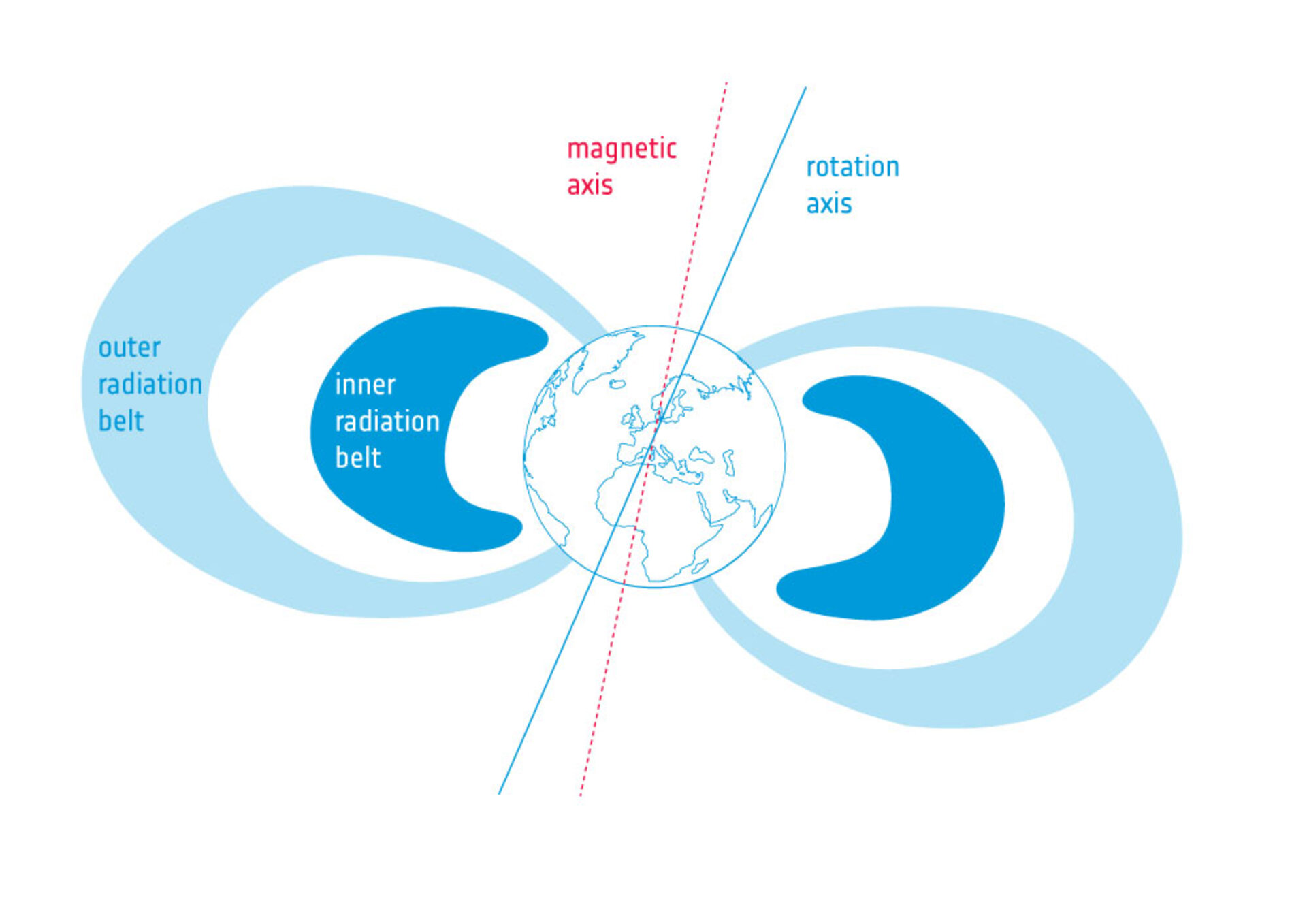
Inner Belt: Located approximately 1,000 to 5,000 kilometers above Earth’s surface. It consists primarily of high-energy protons with energies exceeding 30 million electron volts (MeV). These protons originate from the decay of neutrons produced when cosmic rays collide with atmospheric atoms.
Outer Belt: Centered at about 15,000 to 20,000 kilometers altitude (though some estimates place it as far as 38,000 kilometers). It contains billions of high-energy electrons and ions originating primarily from the solar wind that become trapped in Earth’s magnetic field.
These belts protect Earth’s surface from dangerous radiation while also posing challenges for satellites and spacecraft passing through them.
Geomagnetic Storms and Aurora
Geomagnetic Storms
When solar activity intensifies—such as during coronal mass ejections—the protective shield of the magnetosphere weakens temporarily. These disturbances are called geomagnetic storms and can last several days. During such events:
The magnetic field strength can fluctuate by more than 1,000 nanoteslas
Charged particles penetrate deeper into the atmosphere along magnetic field lines near the poles
Intense currents flow through the magnetosphere, creating changes in radiation belts and the ionosphere
Technological Impacts:
Geomagnetic storms can significantly affect modern infrastructure:
Power Grids: Geomagnetically induced currents (GICs) in power lines can saturate transformers, potentially causing blackouts
Satellite Operations: Surface charging, increased drag from atmospheric expansion, and radiation damage can disrupt or destroy satellites
Navigation Systems: GPS and other Global Navigation Satellite Systems (GNSS) experience errors due to ionospheric disturbances
Communications: Radio signals, particularly high-frequency (HF) communications, can be disrupted
Aviation: Increased radiation exposure at high altitudes poses risks to aircraft and crew
The 1989 geomagnetic storm in Canada demonstrated these impacts dramatically, causing a complete power grid collapse in Quebec.
Aurora Formation
The aurora borealis (northern lights) and aurora australis (southern lights) are spectacular visual manifestations of geomagnetic activity. The formation process involves: 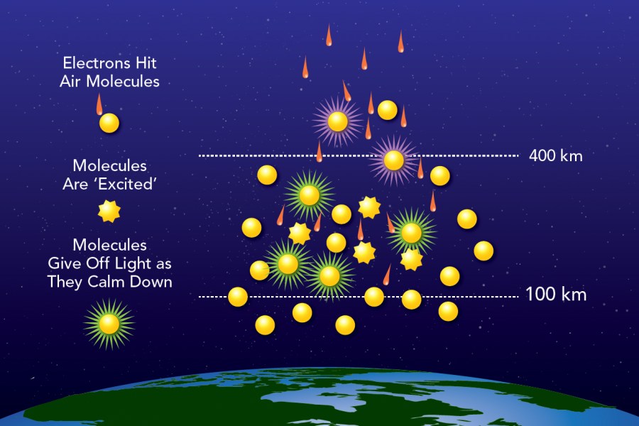
Charged particles from solar wind penetrate the magnetosphere during magnetic disturbances
These particles are accelerated along magnetic field lines toward the polar regions
At altitudes typically around 80 miles (130 kilometers) above Earth’s surface, the particles collide with atmospheric oxygen and nitrogen atoms
The collision excites these atmospheric atoms, causing them to emit light as they return to their normal energy state
Different gases produce different colors: oxygen creates green and red auroras, while nitrogen produces blue and purple displays
The characteristic wavy patterns and curtain-like structures of auroras are shaped by Earth’s magnetic field lines.
Magnetic Pole Movement and Reversals
Pole Wandering
Earth’s magnetic poles are not stationary but constantly move. Historical observations reveal:
Traditionally, the poles wandered slowly at approximately 9 kilometers per year
Since the turn of the 21st century, this speed has increased dramatically to 50 kilometers per year
The Magnetic North Pole has shifted from northern Canada toward Siberia in recent decades
Geomagnetic Reversals
One of the most remarkable features of Earth’s magnetic field is its ability to completely reverse polarity, with magnetic north and south poles exchanging positions. Key facts about reversals:
Frequency: Geomagnetic reversals have occurred hundreds of times throughout Earth’s history, happening on average every 300,000 years (though intervals vary considerably). The last complete reversal occurred approximately 780,000 years ago (the Brunhes-Matuyama reversal).
Duration: A complete reversal takes anywhere from a century to 20,000 years to complete. During this transition period, the magnetic field weakens significantly—potentially to about 10% of its normal strength—and multiple north and south poles may temporarily exist.
Causes: Reversals emerge spontaneously from the dynamics of the geodynamo. Computer simulations show that the solid inner core plays a crucial role in controlling the reversal process, as it “resists” new field orientations until existing magnetic fields locked within it diffuse away.
Environmental Impacts: The Laschamps Excursion (41,000-42,000 years ago) provides evidence of reversal impacts. During this event:
Global cosmic ray flux reaching Earth’s atmosphere increased up to three times higher than today
The weakened magnetic field may have contributed to environmental stress and possibly affected megafauna populations
However, direct links between reversals and mass extinctions remain controversial, as reversals occur much more frequently than mass extinction events
Current Status: Earth’s magnetic field has weakened approximately 10% over the last 200 years. Some scientists suggest this could indicate an approaching reversal, while others note that field strength remains higher than the historical average for the past 50,000 years.
South Atlantic Anomaly
The South Atlantic Anomaly (SAA) represents a region over South America and the southern Atlantic Ocean where Earth’s magnetic field is unusually weak. This anomaly exists because the inner Van Allen radiation belt approaches closest to Earth’s surface in this region.
Characteristics and Effects:
The SAA creates a zone where satellites experience increased exposure to energetic particles
Space Shuttle missions recorded absorbed dose rates of 112-175 μGy/day in this region
The International Space Station requires extra shielding to protect against SAA radiation
The Hubble Space Telescope does not conduct observations while passing through the SAA
Modern laptop computers have crashed when spacecraft passed through the anomaly
Movement and Evolution:
Recent observations show the SAA is both expanding and weakening:
It moves at approximately 0.06° northward and 0.28° westward per year
The anomaly’s valley has split into two lobes, creating additional challenges for satellite missions
Applications of Earth’s Magnetic Field
Navigation
For centuries, Earth’s magnetic field has been fundamental to navigation through the use of magnetic compasses. The compass needle aligns with the horizontal component of the magnetic field, pointing toward magnetic north. While GPS has largely replaced magnetic compass navigation in modern times, understanding magnetic declination remains important for accurate navigation, especially in remote areas.
Animal Navigation and Migration
Numerous animal species use Earth’s magnetic field for navigation during migration and homing behavior:
Sea Turtles: Loggerhead sea turtles possess remarkable magnetic navigation abilities. Research demonstrates that they can:
Use magnetic information as both a compass (for direction) and a map (for location)
Learn and remember the magnetic signatures of specific geographical areas, such as feeding and nesting sites
Distinguish between locations differing in both latitude (north-south) and longitude (east-west) using magnetic cues
Birds: Many migratory bird species use magnetoreception for long-distance navigation, detecting both the direction and intensity of magnetic field lines.
Other Species: Magnetic navigation has been documented in diverse organisms including salmon, lobsters, mole rats, and various insects.
Paleomagnetism and Geological Applications
Rock Magnetism
Paleomagnetism studies the permanent magnetization recorded in rocks, providing crucial insights into Earth’s magnetic history and geological processes. The process works as follows:
Formation of Magnetic Records:
When igneous rocks cool through the Curie temperature (approximately 570°C for magnetite, the most common magnetic mineral), magnetic minerals within the rocks align with Earth’s magnetic field at that time. This alignment becomes “frozen” into the rock as it solidifies, preserving a permanent record of the field’s direction and intensity.
For sedimentary rocks, small magnetic grains orient themselves according to the magnetic field as they settle and before final consolidation, creating detrital remanent magnetism.
Evidence for Plate Tectonics
Paleomagnetism provided crucial evidence for the theory of plate tectonics through the discovery of magnetic striping on the ocean floor:
Magnetic Striping Pattern:
At mid-ocean ridges where tectonic plates diverge, rising magma assumes the polarity of Earth’s magnetic field before solidifying. As new oceanic crust forms and moves away from the ridge due to seafloor spreading, subsequent eruptions record the magnetic field at later times. Because Earth’s magnetic field reverses periodically, this creates alternating bands of normal and reversed polarity—a pattern of magnetic stripes symmetrically arranged on both sides of mid-ocean ridges.
This discovery, formalized in the Vine-Matthews-Morley hypothesis (1963), revolutionized geology by:
Providing direct evidence for seafloor spreading
Allowing calculation of spreading rates by measuring distances between reversals of known ages
Creating a natural “tape recording” of geomagnetic field reversal history
Monitoring and Research
Swarm Mission
The European Space Agency’s Swarm mission, launched in November 2013, represents the most advanced effort to monitor Earth’s magnetic field. The mission consists of three identical satellites in polar orbits:
Constellation Configuration:
Swarm A and C orbit at approximately 450-470 km altitude with a separation of 1.4° longitude
Swarm B orbits at approximately 520-530 km altitude
This configuration optimizes spatial and temporal sampling to distinguish different magnetic sources
Instrumentation:
Each satellite carries sophisticated instruments:
Vector Field Magnetometer (VFM): Measures the direction of the magnetic field with 50 Hz sampling rate
Absolute Scalar Magnetometer (ASM): Measures field strength with accuracy better than 0.3 nT
Electric Field Instrument (EFI): Measures plasma density, drift, and acceleration
Accelerometer: Measures air drag, winds, Earth albedo, and solar radiation pressure
The mission has provided unprecedented insights into magnetic field variations, ocean tidal magnetic signatures, and the distribution of subsurface magma.
Key Points to Remember
Earth’s magnetic field is generated by the geodynamo process in the liquid outer core through convection of molten iron and nickel
The magnetosphere extends 60,000-70,000 km and protects Earth from solar wind and cosmic radiation
Seven parameters describe the magnetic field: declination (D), inclination (I), total intensity (F), horizontal component (H), vertical component (Z), north component (X), and east component (Y)
Field strength is measured in nanotesla (nT), ranging from 25,000-65,000 nT on Earth’s surface
Van Allen radiation belts trap charged particles at 1,000-5,000 km (inner) and 15,000-20,000 km (outer) altitudes
Geomagnetic storms can disrupt power grids, satellites, GPS systems, and communications
Aurora occurs when charged particles collide with atmospheric gases along magnetic field lines near poles
Magnetic poles move continuously; currently shifting at 50 km/year
Geomagnetic reversals occur on average every 300,000 years, with the last one 780,000 years ago
The South Atlantic Anomaly is a weak spot where radiation belts approach closest to Earth’s surface, affecting satellites
Paleomagnetism in rocks provides evidence for plate tectonics through magnetic striping patterns at mid-ocean ridges
The Curie temperature for magnetite is 570°C, below which rocks record magnetic field direction
Animals like sea turtles and birds use magnetoreception for navigation and migration
ESA’s Swarm mission monitors Earth’s magnetic field with unprecedented accuracy using three satellites
Daily Static Quiz
Discover more from Simplified UPSC
Subscribe to get the latest posts sent to your email.


