Sites of Indus Valley Civilization
Contents
Sites of Indus Valley Civilization: Comprehensive Notes
Introduction
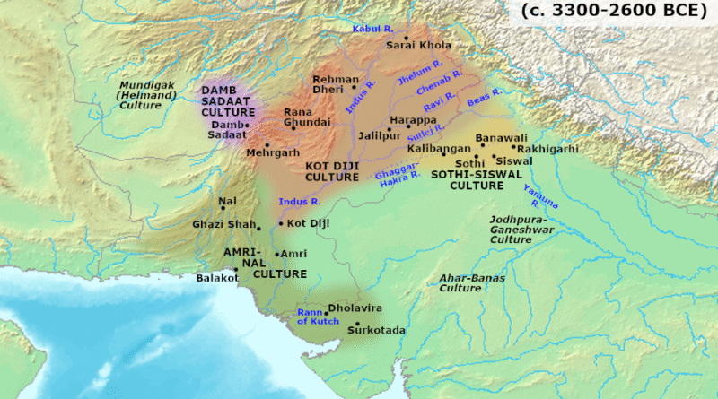
The Indus Valley Civilization (IVC), also known as the Harappan Civilization, flourished between approximately 2600–1900 BCE in the region of the Indus River and its tributaries. Over 1,052 settlements have been identified, with approximately 96 excavated. These sites are distributed across modern-day Pakistan, India, and Afghanistan. The civilization was spread over an area of approximately 1.3 million square kilometers, making it one of the world’s largest Bronze Age civilizations.

Major Indus Valley Civilization Sites
1. HARAPPA
Location: Punjab province, Pakistan (on the left bank of the Ravi River)
River System: Ravi River
Discovery & Excavation:
First discovered in 1921 by Daya Ram Sahni of the Archaeological Survey of India
Further excavations were conducted under the direction of Sir John Marshall, Director-General of ASI, from 1921-1922 onwards
This was the first site of the Indus Valley Civilization to be discovered
Key Features:
First urban centre to be excavated
Contains remains from Early, Mature, and Late Harappan phases
Well-planned grid layout with streets intersecting at right angles
Six granaries arranged in two rows (the most significant finding)
Standardized burnt bricks used in construction
Cemetery H (burial ground) with coffin burials
Evidence of phallus worship and Mother Goddess figurines
Drainage system with underground channels and soak pits
Male torso and red sandstone sculptures
Seals with typical Harappan symbols and script
Significance: Harappa represents urban sophistication and demonstrates surplus agricultural production supporting non-agricultural specialists and trade networks.
2. MOHENJODARO
Location: Larkana district, Sindh Province, Pakistan (approximately 5 km from the Indus River)
River System: Indus River
Discovery & Excavation:
Discovered in 1922 by R.D. Banerjee (initial identification)
Extensively excavated under Sir John Marshall and later archaeologists
Sir Mortimer Wheeler led additional excavations in the 1930s
Excavations continued through the 1960s-70s with George F. Dales
Key Features:
Name means “Mound of the Dead”
Most prominent and largest site of the Harappan Civilization
Two main zones: citadel (upper town) and lower town
Great Bath — the most distinctive structure; possibly used for ritual purposes
Largest public structure with sophisticated waterproofing (watertight construction using bitumen)
Great Granary — consisting of 27 blocks of brickwork crisscrossed by ventilation channels
Advanced underground drainage system
Terracotta and stone figurines
Pashupati Seal (discovered 1928) — depicting a horned deity with three faces resembling Hindu deity Shiva; dated to 2300 BCE
Statue of a Dancing Girl (Bronze figurine)
Priest-King statue (bearded head with inlaid eyes)
Ivory weight balances
Evidence of the Indus script on clay tablets and seals
Multi-storied brick houses with wells and bathing platforms
Significance: Mohenjo-Daro exemplifies the sophistication of urban planning, public infrastructure, and ritualistic practices of the Indus Valley Civilization.
3. KALIBANGAN
Location: Hanumangarh district, Rajasthan, India (on the left bank of the now-dry Ghaggar River, approximately 310 km northwest of Delhi)
River System: Ghaggar-Hakra River (considered the dried-up remains of the legendary Saraswati River)
Discovery & Excavation:
First identified as a prehistoric site by Luigi Pio Tessitori, an Italian Indologist (1887-1919)
Recognized as a Harappan site by Amlanand Ghosh (Ex-Director General, ASI) in 1950-53
Major excavations from 1960–1969 under B.K. Thapar, M.D. Khare, K.M. Shrivastava, and S.P. Jain
Supervised by B.B. Lal (then Director General, ASI)
Key Features:
Name derived from “Kali” (black) and “Bangan” (bangles) — named after terracotta bangles found here
Provincial capital of the Indus Valley Civilization
Three-mound structure (largest centre, smallest west, smallest east)
Both pre-Harappan and Harappan settlement layers discovered
Fire altars — evidence of animal sacrifice, unique to this site
World’s earliest attested ploughed fields — showing evidence of irrigation and agricultural practices
Trepanned skulls — indicating advanced surgical knowledge and medical practices
Lower and upper fortified towns with grid pattern layout
Well-planned streets and drain systems
Wooden drainage channels
Copper and terracotta figurines
Copper ox (bullocks)
Evidence of earthquake damage on structures
Shell and stone ornaments
Boustrophedon style writing — text written alternately from right to left and left to right
Significance: Kalibangan provides crucial evidence of agricultural practices, ritual and religious beliefs, and demonstrates pre-Harappan cultural transitions.
4. LOTHAL
Location: Ahmednagar district, Gujarat, India (in the Kutch region, along the Bhogava River, a tributary of the Sabarmati River, near the Gulf of Khambat)
River System: Bhogava River (Sabarmati tributary)
Discovery & Excavation:
Excavated under the direction of S.R. Rao of the Archaeological Survey of India
Full remains date from 2400–1600 BCE (Late Harappan phase)
Key Features:
Only port-town of the Indus Valley Civilization
Unique tidal dockyard — a basin measuring approximately 217 m long and 26 m wide with inlet and outlet channels
Evidence of wharf and maritime trade infrastructure
Upper town (citadel) and lower town divisions
Citadel demarcated by mud-brick platforms (4 m height)
Large warehouse structure with square platform
Bead-making factory in the lower town
Bead production at industrial scale — carnelian beads, semi-precious stones
Graveyard with double burials
Fire altars
Evidence of rice cultivation (early evidence in the subcontinent)
Thick peripheral walls (12–21 meters) designed to withstand tidal floods
Trade evidence: seals and artifacts tracing origins to Persian Gulf and Mesopotamia
Copper weights and ivory weight balances
Stone anchors and marine shells
UNESCO World Heritage Site designation
Significance: Lothal demonstrates maritime trade networks, sophisticated port engineering, and the economic importance of bead production and export.
5. DHOLAVIRA
Location: Kutch district, Gujarat, India (near the village of Dholavira)
River System: Between Mansar and Manhar seasonal streams
Discovery & Excavation:
Excavated by R.S. Bisht (Archaeological Survey of India) from 1990 onwards
Major excavations continued under his direction establishing it as a significant site
Key Features:
Name “Kotada” in local dialect
Inhabited between 3000–1800 BCE (1,200-year occupation)
Fifth-largest Indus Valley Civilization site
Unique three-part city plan: Citadel, Middle Town, and Lower Town
Only site with urban zoning divisions clearly marked
Advanced water management system — world’s earliest known reservoir system with dams and embankments
Multiple reservoirs and water channels for water conservation
Stone architecture instead of typical baked bricks
Large signboard with Harappan script (largest inscription found)
City gates and fortified structures
Ceremonial ground
Cemetery to the west
Massive stepped reservoirs (baolis)
Rock-cut architecture
Tropic of Cancer passes through this site
UNESCO World Heritage Site (2021)
Significance: Dholavira exemplifies sophisticated water management systems, long-term urban planning, and adaptation to arid climate.
6. RAKHIGARHI
Location: Hisar district, Haryana, India (approximately 150 km northwest of Delhi, on the Ghaggar-Hakra River plain)
River System: Ghaggar-Hakra River
Discovery & Excavation:
First discovered in 1963 by the Archaeological Survey of India
Excavations by Amarendra Nath (ASI) from 1997–2000
Dr. Vasant Shinde (Deccan College, Pune) from 2012–2016
Dr. Sanjay Manjul (Institute of Archaeology) from 2022 onwards
Currently the largest-known Harappan site
Key Features:
Largest Indus Valley Civilization site with 300–350 hectares of archaeological remains
Nine main mounds originally; two additional mounds discovered in 2014 (Mounds 1–9)
RGR-7 represents a cemetery and burial ground of the mature phase
Early, Mature, and Late Harappan phase evidence
Paved roads and streets with grid layout
Advanced drainage systems
Large rainwater collection and storage systems
Terracotta and baked brick construction
Evidence of statue and sculpture production
Skilled working of bronze and precious metals
Gold foundry with approximately 3,000 unpolished semi-precious stones
Jewelry including bangles (terracotta, conch shells, gold, semi-precious stones)
Tools for polishing stones, furnaces
Bronze vessels decorated with gold and silver
Copper fish hooks, needles, and combs
Terracotta seals with Indus script
Complete skeletal remains (4,600 years old) with burial goods including pottery and shell bangles
DNA analysis of skeletal remains — earliest DNA evidence of Indus inhabitants
Evidence of animal sacrifice and fire altars
Significance: Rakhigarhi provides critical genetic and anthropological data about the Indus Valley population and represents the northern boundary of mature Harappan settlements.
7. BANAWALI
Location: Fatehabad district, Haryana, India (approximately 120 km northeast of Kalibangan)
River System: Saraswati River (now dried up)
Discovery & Excavation:
Excavated by R.S. Bisht (Archaeological Survey of India) in 1973–1974
Located on the upper middle valley of the Saraswati River (compared to Kalibangan in lower middle valley)
Key Features:
Earlier called “Vanavali”
Three cultural periods identified:
Period I (c. 2500–2300 BCE): Pre-Harappan (Kalibangan phase)
Period II (c. 2300–1700 BCE): Mature Harappan
Period III (c. 1700–1500/1450 BCE): Post-Harappan (Banawali-Bara phase)
Well-planned houses constructed from kiln-burnt and moulded bricks
Defence wall measuring 105 m length, 4.5 m height, and 6 m width
Chess-board pattern fortified town (200 m × 500 m)
Two adjacent areas: one for ruling class, one for common people
North-south thoroughfares intersecting at right angles with east-west lanes
Houses with rammed earth floors, mud-plastered walls, rooms, kitchens, and toilets
Storage facilities similar to strongrooms at other sites
Replica of the plough discovered
Clay figurine of Mother Goddess
Pottery assemblage similar to Kalibangan I period
Typical Harappan pottery (vases, jars, vessels)
Significance: Banawali represents a transitional settlement and provides evidence of agricultural practices and continuity from pre-Harappan to Harappan cultures.
8. CHANHUDARO
Location: Sindh Province, Pakistan (approximately 12 miles east of the present-day Indus River bed)
River System: Indus River basin
Discovery & Excavation:
First excavated by N.G. Majumdar in March 1931
Re-excavated during winter session 1935–36 by Ernest John Henry Mackay (American School of Indic and Iranian Studies and Boston Museum of Fine Arts)
Further exploratory work by Mohammed Rafique Mughal after Pakistan’s independence
French Archaeological Mission in the Indus Basin (MAFBI) directed by Aurore Didier (CNRS) since 2015
Key Features:
Group of three low mounds forming parts of a single settlement (~7 hectares)
Only major Indus Valley Civilization site without a citadel
Centre for specialized bead manufacturing — particularly carnelian beads
Settlement period: 4000–1700 BCE
Evidence of mass production facilities
Copper tools and metal items: knives, spears, razors, tools, axes, vessels, dishes, fish hooks
Nicknamed “Sheffield of the British Empire” by Ernest Mackay (due to copper production)
Terracotta cart models with seated driver
Small terracotta bird (whistle when blown)
Ceramic dishes and plates
Inkpot (evidence of writing materials)
Pottery of various types
No major public monuments or granary
Significance: Chanhudaro demonstrates specialized craft production and industrial organization in Indus Valley society.
9. SUTKAGANDOR
Location: Baluchistan, Pakistan (Makran coast, approximately 480 km west of Karachi, near Gwadar, close to the Iranian border, Union Council of Suntsar)
River System: Dasht River and Gajo Kaur (smaller stream)
Discovery & Excavation:
Discovered in 1876 by Major Edward Mockler (Assistant Political Agent, Makran Coast)
Visited and excavated by Aurel Stein in 1928 (as part of his Gedrosia tour)
Extensively excavated in October 1960 by George F. Dales (University of California, Berkeley) as part of his Makran Survey
Key Features:
Westernmost known Indus Valley Civilization site
Smaller settlement measuring approximately 4.5 hectares (300 m × 150 m)
Citadel and lower town divisions
Massive stone fortification walls of semi-dressed stones (7.5 m thick at base at one point)
Citadel wall varying in height due to irregular rock foundation
Inner face of wall slightly battered; outer face at 23°–40° slope
Structures made from stone and mud bricks without straw
Trade post and defensive settlement
Maritime trade links with Mesopotamia
Copper-bronze disc (possibly BMAC — Bactria-Margiana Archaeological Complex association)
127 flint blades without cores (up to 27.5 cm length)
Stone vessels and arrowheads (stone and copper)
Shell beads and pottery
Evidence of trade networks extending westward
Significance: Sutkagan Dor marks the western boundary of the Indus Valley Civilization and demonstrates maritime trade connections.
10. BALAKOT (KOT BALA)
Location: Lasbela District, Balochistan, Pakistan (near Makran coast of the Arabian Sea, interior of Sonmiani Bay)
River System: Arabian Sea coast
Discovery & Excavation:
Excavated by Professor George F. Dales (University of California, Berkeley) from 1963–1976
Only professionally excavated site in the region
Key Features:
Settlement predates Indus Valley Civilization by many centuries (around 4000 BCE)
Lower levels show pre-Harappan culture; upper levels represent Indus influence
Arrival of Indus influence was sudden (not gradual evolution)
Coastal settlement near Arabian Sea
Shell processing units
Bead-making factory
Evidence of harboring facilities for Indus traders
Earliest evidence of furnace structures
Important maritime harbour for Indus traders sailing to Arabian Peninsula coasts
Importance for trade route studies
Significance: Balakot demonstrates the extent of Indus maritime trade networks and cultural expansion.
11. ALAMGIRPUR
Location: Meerut district, Uttar Pradesh, India (on Hindon River, Ganga-Yamuna Doab, approximately 25 km west of Meerut, ~28 km from Delhi)
River System: Hindon River (tributary of Yamuna)
Discovery & Excavation:
First excavated by Bharat Sewak Samaj (1958), with pottery and beads discovered
Examined by Y.D. Sharma (North-Western Circle, Department of Archaeology), who identified Harappan affiliation
Partially excavated by Archaeological Survey of India in 1958–1959
Key Features:
Easternmost known site of the Indus Valley Civilization
Known as Parshuram ka Tila/Khera (Parshuram’s Mound)
Dimensions: 60 m east-west, 50 m north-south, 6 m average elevation
Settlement thrived along Yamuna River (c. 3300–1300 BCE)
Four cultural periods identified with intervening breaks
Earliest level dated 2600–2200 BCE (calibrated)
Kiln-burnt bricks (11.25–11.75 in. length, 5.25–6.25 in. breadth, 2.5–2.75 in. thickness)
Pottery workshop complex
Typical Harappan pottery: roof tiles, dishes, cups, vases, cubicle dice, beads
Terracotta cakes, carts, and figurines (humped bull and snake)
Beads of steatite paste, faience, glass, carnelian, quartz, agate, and black jasper
Possibly ear studs made of semi-precious stones
Small gold-coated terracotta bead
Evidence of cloth impressions on a trough — indicating weaving technology
Copper blade fragment
Bear head fragment (part of vessel)
Painted Grey Ware (PGW) pottery
Terracotta figurines and ornaments
Significance: Alamgirpur marks the eastern extent of Indus Valley Civilization and demonstrates craft specialization in bead production.
12. DAIMABAD
Location: Ahmednagar district, Maharashtra, India (on the western edge of the Deccan plateau)
River System: Godavari River basin
Discovery & Excavation:
Discovered by B.P. Bopardikar in 1958
First excavation (1958–59) under M.N. Deshpande (ASI)
Second excavation (1974–75) under S.R. Rao (ASI)
Third excavations (1975–76 to 1978–79) under S.A. Sali (ASI)
Key Features:
Southernmost known site of the Indus Valley Civilization
Represents Harappan expansion into the Deccan region
Evidence of Late Harappan culture extending into south India
Four bronze sculptures discovered:
Chariot (representing warfare and mobility)
Bull (sacred animal)
Elephant (symbol of wealth and power)
Rhinoceros
Shows IVC influence in Deccan Plateau
Cultural exchange with Deccan societies
Maharashtra’s major chalcolithic site
Settlement abandoned at transition to later period
Significance: Daimabad demonstrates the geographical reach and cultural expansion of the Indus Valley Civilization southward and challenges traditional boundaries.
Summary Table: Major Indus Valley Civilization Sites
| Site | Location | River | Discoverer/Excavator | Key Period | Prime Features |
|---|---|---|---|---|---|
| Harappa | Punjab, Pakistan | Ravi | Daya Ram Sahni (1921) | 2600–1900 BCE | Six granaries, cemetery, urban grid |
| Mohenjo-daro | Sindh, Pakistan | Indus | R.D. Banerjee (1922) | 2600–1900 BCE | Great Bath, granary, drainage system |
| Kalibangan | Rajasthan, India | Ghaggar | Luigi Tessitori / Amlanand Ghosh (1950–53) | 2600–1900 BCE | Fire altars, ploughed fields, pre-Harappan layer |
| Lothal | Gujarat, India | Bhogava | S.R. Rao | 2400–1600 BCE | Port, tidal dockyard, bead factory |
| Dholavira | Gujarat, India | Mansar/Manhar | R.S. Bisht (1990+) | 3000–1800 BCE | Water reservoirs, three-part city, urban zoning |
| Rakhigarhi | Haryana, India | Ghaggar-Hakra | ASI / Amarendra Nath (1997–2000) | Early-Mature-Late phases | Largest site, gold foundry, burial ground |
| Banawali | Haryana, India | Saraswati | R.S. Bisht (1973–74) | 2500–1450 BCE | Plough replica, fortified town, three phases |
| Chanhudaro | Sindh, Pakistan | Indus basin | N.G. Majumdar (1931) | 4000–1700 BCE | Bead factory, no citadel, craft centre |
| Sutkagan Dor | Baluchistan, Pakistan | Dasht River | Major Mockler (1876) | Harappan | Westernmost site, stone fortification, trade post |
| Balakot | Balochistan, Pakistan | Arabian Sea coast | George F. Dales (1963–76) | Pre-Harappan to Harappan | Shell processing, harbour, maritime trade |
| Alamgirpur | Uttar Pradesh, India | Hindon River | Y.D. Sharma (1958–59) | 2600–2200 BCE | Easternmost site, cloth impressions, pottery workshop |
| Daimabad | Maharashtra, India | Godavari basin | B.P. Bopardikar (1958) | Late Harappan | Southernmost site, bronze sculptures, Deccan expansion |
River Systems of Indus Valley Civilization
Indus River System:
The IVC developed primarily along:
Indus River — Main river; major sites: Mohenjo-daro, Harappa
Ravi River — Eastern tributary; site: Harappa
Sutlej River — Eastern tributary; formerly flowed into Ghaggar
Ghaggar-Hakra River — Now dry; historical Saraswati River; sites: Kalibangan, Rakhigarhi, Banawali
Bhogava River — Western tributary; site: Lothal
Hindon River — Eastern extent; site: Alamgirpur
Distribution and Extent
Northern boundary: Shortughai (Afghanistan)
Western boundary: Sutkagan Dor (Iranian border)
Eastern boundary: Alamgirpur (Uttar Pradesh)
Southern boundary: Daimabad (Maharashtra)
Total area: Approximately 1.3 million square kilometers
Total sites identified: 1,052 settlements
Excavated sites: ~96 sites
Check other notes: Ancient India
Discover more from Simplified UPSC
Subscribe to get the latest posts sent to your email.


