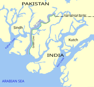
Sir Creek Dispute Between India and Pakistan
Contents
Sir Creek Dispute Between India and Pakistan
Geographical Location
Sir Creek is a 96-kilometer tidal estuary located in the marshlands of the Rann of Kutch, forming a strategic boundary between India’s Gujarat state and Pakistan’s Sindh province. Originally known as Ban Ganga, it was renamed Sir Creek after a British surveyor during the colonial period. The creek flows northward through the Great Rann of Kutch and empties into the Arabian Sea, separating the Kutch district of Gujarat from Pakistan’s Sindh province.
The terrain is characterized by flat, marshy salt mudflats that are prone to tidal changes, making demarcation extremely difficult. The area is largely uninhabited and experiences harsh conditions, with scorching days and freezing nights, and is home to Russell’s vipers and scorpions. During monsoon season (June to September), the creek floods its banks and envelops the surrounding low-lying salty mudflats.

Claims by Both Parties
Pakistan’s Claim
Pakistan claims the entire Sir Creek based on the 1914 Bombay Government Resolution signed between the government of Sindh and the rulers of Kutch. According to Paragraph 9 of this agreement, the boundary lies “to the east of the Creek,” which implies that the entire creek belongs to Sindh (now part of Pakistan). Pakistan argues that Sir Creek is non-navigable and contends that the thalweg principle applies only to rivers, not tidal estuaries.
India’s Claim
India argues that the boundary should run along the middle of the navigable channel, invoking the Thalweg Principle. India cites a 1925 map and mid-channel pillars to support its position. India maintains that while the creek’s flow fluctuates, it remains navigable and is frequented by fishermen, making the mid-channel principle applicable. India also points to Paragraph 10 of the same 1914 resolution, which invoked the Thalweg Principle.
The dispute stems from contradictory provisions within the same 1914 resolution, creating inherent ambiguity in boundary interpretation.
Importance to India
Strategic Significance
Sir Creek holds immense strategic importance for India as it lies near the area where Indian and Pakistani troops clashed during the 1965 war. The creek serves as India’s westernmost border with Pakistan and is crucial for coastal security and surveillance. India maintains specialized BSF “Creek Crocodile Commandos” and amphibious patrols to guard this sensitive frontier.
Maritime Boundary Delimitation
Control over Sir Creek is critical as it serves as the baseline for drawing maritime boundaries in the Arabian Sea. The land-end point of Sir Creek determines the demarcation of Exclusive Economic Zones (EEZs) and continental shelf rights between both countries. This affects thousands of square kilometers of offshore areas for fishing, oil, and gas exploitation.
Economic Value
Sir Creek is strategically located near one of Asia’s largest fishing grounds, supporting the livelihoods of thousands of Indian fishermen. The area is believed to contain significant untapped oil and gas reserves under the seabed, though exploration remains stalled due to the ongoing dispute. The creek also lies close to major shipping routes in the Arabian Sea, making it strategically important for maritime trade.
Water Security Issues
Pakistan’s Left Bank Outfall Drain (LBOD) project discharges saline water into Sir Creek, which India argues violates the Indus Waters Treaty by flooding Kutch with saline effluents.
Ecologically Important Habitat
Biodiversity Significance
Sir Creek represents an ecologically fragile and vital ecosystem within the Indus River Delta. The area is part of the larger wetland complex that supports remarkable biodiversity and serves as a crucial habitat for various species.
Avian Diversity
During winter months, the creek becomes home to flamingos and other migratory birds, including pelicans, herons, and egrets. The area supports various wader species and raptors, making it an important stopover point on migratory routes. The region attracts thousands of migratory waterbirds annually, qualifying it as an Important Bird Area.
Mangrove Ecosystem
The Sir Creek area is part of a larger mangrove ecosystem that includes 15 mangrove species belonging to 10 genera and 6 families in the Indus deltaic region. The dominant species is Avicennia marina, which comprises about 90% of the mangrove cover. Other species include Rhizophora mucronata, Aegiceras corniculatum, and Ceriops tagal.
Marine Life
The creek serves as critical spawning grounds and nurseries for fish and aquatic crustaceans. The mangrove forests provide important habitat for invertebrates and vertebrate species. Marine mammals recorded in the area include Humpbacked Dolphin, Bottlenosed Dolphin, and Finless Porpoise.
Conservation Status
Pakistan has declared the western side of Sir Creek area as part of the Keti Bunder South Wildlife Sanctuary and designated it as a Ramsar wetland since 2002 as part of the Indus Delta region. The area qualifies for Ramsar status due to its support for significant populations of waterbirds and its role as a critical habitat for migratory species.
Environmental Challenges
The ecosystem faces threats from reduced freshwater flows from the Indus River, increased salinity levels, and pollution from industrial effluents. Climate change impacts and human activities pose additional challenges to this fragile wetland ecosystem.
The Sir Creek dispute represents more than a boundary disagreement—it involves the protection and management of one of South Asia’s most ecologically significant wetland systems. The resolution of this dispute could pave the way for joint conservation efforts that would benefit both countries while preserving this critical biodiversity hotspot for future generations.
Context: The Hindu
Discover more from Simplified UPSC
Subscribe to get the latest posts sent to your email.

